Lake Erie Commercial fishing
 Commercial fishing in the Great Lakes has experienced dramatic changes in target species and harvest levels due to the combined influences of over-fishing, invasive species introductions, and environmental degradation occurring over the past 200 years.1, 2
Historically, each of the Great Lakes supported sizeable commercial fisheries, and the total basin-wide harvest regularly exceeded 100 million round pounds of fish. Booms in commercial fish harvest were associated with expanded fishing effort, emerging technologies, and natural fish population fluctuations.
Historcially important Great Lakes commercial fish stocks include:
American eel
Blue pike
Carp
Chub (deepwater cisco spp.)
Lake herring (cisco)
Lake sturgeon
Lake trout
Lake whitefish
Round whitefish
Walleye
Yellow perch
Invasive alewife and smelt also became significant commercial fisheries in the 1970s and 1980s.3
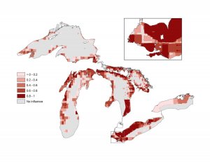
Today, Great Lakes commercial harvests are much diminshed from their historic highs. Repeated fishery collapses are tied to overharvest, habitat degradation, pollution, species invasions, and other factors.4 Since 2000, basin-wide commercial harvests have hovered near 50 million round pounds.3
Lake Erie currently supports the largest commercial fishery in the Great Lakes. Walleye and yellow perch are the most harvested species, and the bulk of the Lake Erie catch is from Canadian waters.
Lake Ontario has the smallest commercial fishery. Harvested species include yellow perch, lake whitefish, bullhead, and Amercian eel.
Lakes Huron, Michigan, and Superior each maintain commercial fisheries for lake whitefish, lake trout, and chub. Other targeted species include:
Lake Superior: lake herring, smelt
Lake Huron: channel catfish, carp, Pacific salmon, yellow perch, and walleye,
Lake Michigan: smelt, yellow perch
Commercial fishing data were obtained from the USGS Great Lakes Science Center (GLSC) (1998-2007) and from the OMNR (2000-2009).
Commercial catch data were recorded in round pounds, or pre-prcessed weight in pounds, at a spatial resolution of 5-minute grid cell for Canada and 10-minute grid cell for the U.S. Exceptions included:
Canadian waters of Lake Ontario: data are recorded at a much coarser “quota zone”
U.S. waters of Lake Ontario: no spatial information was associated with the data; Data for the U.S. waters of Lake Ontario were distributed to a relatively confined area (Chaumont Bay) with a smaller amount being distributed near Fox and Grenadier Islands based on communications with fisheries biologists.
Finally, the data were resampled to our working resolution (1-km grid cells) using the cubic convolution algorithm in ArcGIS.
Source: www.greatlakesmapping.org
Related posts
JANUARY 22, 2026
ERIE, Pa. - Since the season’s May 1 opening, Lake Erie walleye haven’t been where anglers think they’re supposed to be…
Read More
JANUARY 22, 2026
Looking for some Great summer fishing? Well, look no more. Walleye fishing 1st Choice Fishing Charters on eastern basin Lake…
Read More

 Commercial fishing in the Great Lakes has experienced dramatic changes in target species and harvest levels due to the combined influences of over-fishing, invasive species introductions, and environmental degradation occurring over the past 200 years.1, 2


